Wednesday, November 30, 2005

Ash Fork - A map-dot on Highway 66 and the Flagstone Capital of the World

Nov. 30, 2005

Late afternoon on the last day of November, I drove into Ash Fork on Old Highway 66. It is here that the longest stretch of unbroken 66 begins; and it ends along the California border. I spent the night in a non-descript run-down RV park alongside I-40.

The town, started in 1882, served the railroad and area ranchers. Eleven years later the entire town burned to the ground and then was rebuilt. In the 1970s many of the town's buildings were destroyed by another fire, and then when Interstate 40 by-passed the town, it nearly died.

Today about the population is about 500, many of them earning a living working in five flagstone yards located around town, ranching, mining, and the new generation of Route 66 travelers.

I had intended to drive down the main street to explore Ash Fork in the morning, but after blinking twice, I was on Highway 89 headed south to Prescott. And in my opinion, there was no reason to turn around and try again.

It occurred to me that I could drive back and take pictures of the flagstone yards, but you've all seen flagstone - though I doubt you've seen so much all in one place.

Burros, decorated bushes, and tacky souvenir shops


Wednesday, November 30, 2005

I eagerly set out for the nearly abandoned mining town of Oatman on the old-old highway 66. With less than a mile to go, I started seeing bushes decorated for the Christmas season. Made a mental note to ask about the bushes when I got to town.

Before I even found a place to park, I was greeted by the (in)famous burros of Oatman. They are feral, semi-domesticated animals that parade the main street, block vehicle traffic, stand on the board walk, and make pests of themselves begging for handouts. Their usual diet, sold in local shops, is carrots. (see photos)


“Every four to six years, burros double their population. One Arizona ranger commented that ‘at that rate, we’ll soon be up to our ears in asses.’”

Between the locals, the Internet and a book I bought, I learned a lot about Oatman. It began about 90 years ago as a mining tent camp and quickly became a flourishing gold-mining center. In 1915, two miners struck a $10 million gold find, and within a year, the town's population grew to more than 3,500. Highest population was about 7,000.

By 1943, most of the mines had closed and the population dwindled. The town’s only purpose was to serve travelers on the old, old route 66. In 1951 a new section of highway 66 was opened that bypassed Oatman. It almost died.

Today there are about 150 residents in this “authentic old western town.” Intriguing false-front buildings sell tacky souvenirs to tourists.

On my way back to Jeremiah, I met one town resident – Mary (I estimate her to be in her late 80s). “How did you like our town?” she asked. As we talked, she told me about herself: born and raised in San Francisco, plays piano and organ, retired to Oatman about 40 years ago, lives by herself and has numerous dogs that get dumped near her home. She moaned the fact that the town looked like Tijuana, Mexico. And I have to agree. Those lovely old buildings and their covered boardwalks are cluttered with tacky stuff hanging outside: t-shirts, suspenders, blankets, etc.

I asked Mary about the decorated bushes. It is an annual contest for residents. Bushes along the highway are decorated for the holidays. It costs $15 to enter the contest, and if your bush is cleaned up by Feb. 1, you get $10 back. Prizes including trophies and money are awarded.

In 1914 a freightliner – trucks pulled by 16 horses – ran between Oatman and Kingman (the forerunner of highway 66). It took two days to travel one way between the two towns. Today this 26-mile road is VERY narrow and mountainous. (photo)

Once I made it down the mountain from Oatman and through Kingman, I continued east on highway 66 that parallels the railway. The map-dot towns along the way included Valle Vista, Hackberry, Valentine, Peach Springs (on the Hualapai Indian Reservation), Truxton, and Seligman (the birthplace of highway 66).

Hackberry General Store along the highway got my attention as I passed – so I found a place to turn around and go back.

“Big mistake. Many make. Rely on horn. Instead of brake.” Said the Burma-Shave signs that were in the side yard of the General Store. Alongside were very old rusted cars, two burros, several outbuildings, Bonnie’s Food Stand, and a 1942 Ford Thunderbird convertible is cherry condition! Welcome to the past.

Bonnie was sitting in a comfortable chair waiting for customers. Weekdays are slow, she explained. After placing my lunch order with Bonnie, I went inside the general store to find every sort of old highway 66 and Elvis memorabilia. I bought the book, “Stories from The Arizona Coast” (referring to Arizona’s Colorado River coastline communities) written by Paul Taylor. I spent a little more than an hour there, learning about the area. Bonnie (72 years old) retired in Hackberry from Santa Barbara. Her other customer while I was there was Fermin Esquival, a Mohave County building inspector. He said the when he goes through Oatman, he just sort of closes his eyes!

When I drove through Peach Springs, I realized that I was only 20 miles south of the Grand Canyon. I saw several herds of antelope along the road. One of Seligman’s café is named “Roadkill Café.” Seligman looks like an interesting town – and it has an RV Park, so I’ll put this town on my “to be explored on another trip” list.


The last 20 miles today were on Interstate 40. I really loved today’s trip! When I parked at the Grand Canyon RV Park in Ash Fork, I noted that on this trip I’ve driven 2,600 miles so far.

Tuesday, November 29, 2005

Nevada to Arizona


Tuesday, Nov. 29, 2005

Highway 160 southeast of Pahrump – no trees, no signs of civilization (except for a few cars and trucks on the road), long stretches of flat ground with scrubby grasses and bushes – to some this would be a boring drive. But not to me. I amuse myself by imagining what it was like for the early explorers and settlers as they crossed these areas.

After a cold night (25-degrees), the sun is quickly warming things up. It is a gorgeous day in Southeastern Nevada. Soon the flat roads changed to foothills, and a sign noted that I was driving through the Spring Mountain National Recreational Area.

Before I knew it, I had topped the pass and was coming down the hill on the outskirts of Las Vegas. No matter where I looked I saw new home construction “shoulder to shoulder.” The homes looked close enough for people to join hands between windows.

I’m sure glad I was driving through mid-morning. As it was, there were masses of vehicles and semi-trucks and the Interstates are under construction. Finally I made it through my various road changes and was headed south towards Laughlin and Bullhead City.

I passed a map-dot named Cal-Nev-Ari. It had a small casino, motel, and “immobile” mobile and manufactured homes. Next came Searchlight, Nevada, with truck stops and a McDonald’s.

Once I made through Laughlin, across the Colorado River, and through Bullhead City, I continued south to the Oatman Highway turnoff to the Blackstone RV Park where I spent the night. I was treated to a beautiful sunset. (photo) I’m expecting tomorrow to be a super interesting day – Oatman and historic highway 66!

Monday, November 28, 2005

Pahrump – strange name for a town


Monday, November 28, 2005

My morning got off to its leisurely start – coffee and a time to read before the sun ever managed to rise. I only had a 60-mile drive south on highway 160 to Terrible’s Lakeside Casino and RV Park in Pahrump.

Along the way I saw a sign for “Matthew’s Short Branch Saloon” (as opposed to a “long branch” saloon?). Actually it should have been named “no branch saloon” because I don’t see any trees around here. And then there was a sign declaring: Madame Butterfly’s Spa and Massages – Truckers Welcome.

After going through so many tiny map-dot towns, I was surprised to find that Pahrump was a good-sized town. I saw the “welcome to Pahrump” sign about 10 miles before I actually saw the main part of town. Woo-hoo! It has Walmart, Walgreens, Sav-on, Albertsons and Smiths grocery stores. I spent some time exploring the town and getting some groceries.

It has five casinos and a winery (gets its grapes from California) along with plenty of small businesses strung out on highway 160 that runs through the town. After so many days at high altitude, I’m now down to 2,600 feet.

This area was originally inhabited by Shoshone Indians, and then was slowly inhabited by American settlers in the late 19th century. The name – Pahrump – comes from the indigenous name “Pah-Rimpi” (Water Rock) because of the abundant artesian wells.

The park is lovely. About 160 RV spaces surround a large man-made lake that is used for fishing, pedal boats and kayaks. The lake is home to ducks and coots; the park has a lot of trees and grassy area and level (yippee!) RV parking sites. (see photos)

It’s been getting dark about 4:30 in the afternoon, giving me lots of evening time to map out the next days route. And this evening’s project included putting a set of tiny, battery-operated lights on the little artificial Christmas tree I bought in Genoa (Nevada). Looks good in the evening with the lights twinkling.

Tomorrow I’ll travel about 150 miles, going through Las Vegas before heading south to Bullhead City. Sounds like a simple route, but I’ll actually be on eight different roads/highways/Interstates to get there.

Sunday, November 27, 2005

Another great day for a drive!


Sunday, November 27, 2005

“For those who aren’t into ‘roughing it,’ RVing is the way to go. RVers find the ultimate combination of miles of uncrowded highways, spectacular scenery, endless outdoor adventure, RV parks with all the amenities and statewide 24-hour dining and entertainment,” says the official Nevada state map.

I’ve been learning a lot about Nevada, The Silver State. Did you know that 87 percent of it is public lands? The state has ten scenic byways – one of which is the Las Vegas Strip.

Here’s more Nevada info:
--Nevada means snow-capped in Spanish
--Besides The Silver State, another nickname is “Battle Born State.”
--The state bird is the Mountain Bluebird, the state animal is the Desert Bighorn Sheep
--There are five “living” ghost towns: Belmont, Berlin, Rhyolite, Tuscarora and Unionville.

Highway 95 – a.k.a. Veterans Memorial Highway – was my road today, and my planned stop for the night was Beatty and the Burro Inn RV Park. The two-lane highway is mostly flat with spurts of traffic including 18-wheelers and other RVs. The road seems to be paralleling a dry lake. Jeremiah was on cruise control most of today’s drive. My odometer passed 2,000 miles for this trip! Speed limit is 70, Jeremiah (and I) prefer 55 to 60!

I went through several very small towns. As I slowed down for Luning a sign said:
“No vehicle containing explosive devices may park in the town of Luning.”

It’s a beautiful day for driving; blue sky and no wind.

As I was entering the tiny mining town of Mina, I could see a lot of water on the highway and also flashing emergency lights. As I passed by I could see that one of the small wooden homes had burned down and was still smoldering. The volunteer fire department must have responded really fast because this house was flanked by other small wooden homes that appeared to be untouched by fire. The town is mostly wood structures, and many of those look abandoned.

Coaldale, Tonopah and Goldfield are the next dots on the map. Nothing remarkable about any of them. This part of the highway parallels Nellis Air Force Range.

The small town of Beatty consisted of just a few streets. The first RV park I came to was less than wonderful, so I continued on to Burro Inn which despite the write up in my RV Directory was deserted. Thankful for being a flexible person (well, most of the time), I continued south, past more “ranches” and a couple tiny map dots, until I came to Amargosa Valley and the Amargosa RV Park.

Enough driving for the day. The park is OK for the night. I’m at 2,350 feet elevation; a big change from the past few weeks. Tomorrow I’ll drive 50 miles to Pahrump to explore the area and spend the night at Terrible's Lakeside RV Park!

Saturday, November 26, 2005

Ranch? Where's the cattle? The barns and corrals?

Saturday, Nov. 26, 2005

And what kind of cowboy would paint his home pink? Or name it Wild Kat Ranch, Cottontail Ranch, Shady Lady Ranch or Bunny Ranch? Yep, brothels are legal and dot the roadsides.

Today I’m drove south on highways 395, 167, and 359 heading to Whiskey Flats RV Park in Hawthorne. My route took me into California for about 65 curvy mountain miles and two high passes – 7,519 and 8,138 feet – before stopping at a scenic overlook to ohh and ahh over the size of Mono Lake before turning back toward Nevada.

It was a fairly windy drive on highway 167/359, although mostly a tailwind. It was my kind of road – fifty miles, no towns, hardly any traffic – allowing me to drive down the center line until I reached the mountainous part of the road. Jeremiah took me up and over another high pass – 7,626 feet – before we reached Hawthorne.

Hawthorne is home to the U. S. Army Ammunition Plant and the U. S. Naval Undersea Warfare Center. Undersea? There’s no sea here but Walker Lake is nearby. Whiskey Flats is a nice, fairly new RV park. Mt. Grant, elevation 11,245 feet, is close. In fact, the town seems to be surrounded by mountains.

It was windy and too cold to do any walking; however I did brave the cold to take a sunset picture (see photo above). (The photo below was the sunrise on Sunday.)

Friday, November 25, 2005

Family time in Nevada

November 20 – 25, 2005

Spending Thanksgiving with family is tops on my list! For the first time I joined my sister Linda and her husband Bob for a Lechien/Slater celebration in Gardnerville, Nevada. This small, mostly agricultural town is at the foot of Tahoe’s mountains.

Also at the foot of these mountains is Walley’s Hot Springs Spa and Resort. I mention this place because Linda’s boss gifted her with two nights there – and Linda’s husband graciously passed up his chance to go with her so I could go instead. During our time at the resort, Linda and I took an early morning water aerobics class (harder than it looks), tried out the various hot spring pools (almost turned into cooked prunes), had massages (marvelous) and a delicious dinner (prime rib and salmon) in the restaurant. A memorable “sister time” outing.

This is sister Linda relaxing in our spacious resort room.


Jeremiah got new vent covers at the local RV dealer – the kind that won’t blow off. Cat tolerated my long absences, seemingly happy to stay in the motorhome because both homes where we stayed had “monsters.” She just isn’t the sociable type when it comes to dogs and cats.

Linda’s son Tim, his wife (Linda #2) and Linda #2's son Anthony hosted Thanksgiving dinner. We had thirteen around the table: Linda’s sons Richard and David and David’s wife Lisa and their four children – and Linda, Bob and I. It was turkey with all the trimmings – and very delicious! Here's a photo of Linda #2 and her son Anthony.


Friday was a wintry day – clouds and rain and cold! When the clouds lifted on Saturday morning we were treated to snowy mountains.

I left Gardnerville on Saturday with two turkey sandwiches and a container of turkey soup to enjoy while on my way to Prescott, Arizona, for more family time.

NOTE: You can email me at:
carolinnewmexico@azulstar.com

Saturday, November 19, 2005

More of the Loneliest Road in America


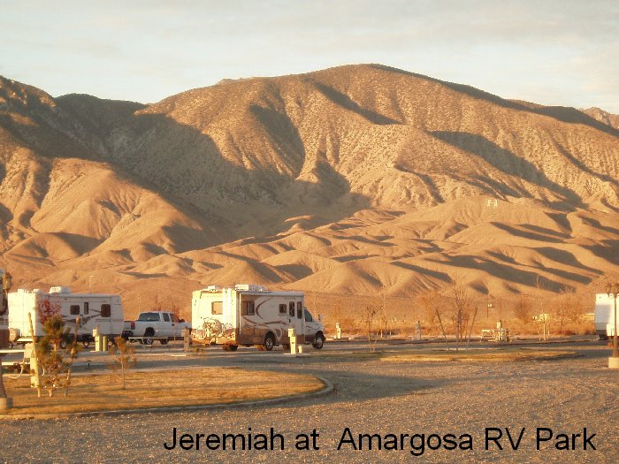
Friday, November, 18, 2005

"It's totally empty. There are no points of interest. We don't recommend it," said an Auto Club counselor in 1986 when asked about Nevada's Highway 50, and then he added, "We warn all motorists not to drive there unless they're confident of their survival skills."

Today's drive was longer than I planned, but in all was a great and very interesting trip. This morning I had intended to walk through Ely's historic downtown to take pictures this morning, but by the time I was ready, it was still really cold. Too cold to be out walking, but I did fill up with gas before leaving.

I headed west on Highway 50. This 287-mile stretch of highway has several distinctions: it became the nation's first transcontinental road, and in 1986 it was named the Loneliest Road in America. It passes nine towns, two abandoned mining camps, and a few gas pumps. It retraces the route of the Pony Express and Overland Stagecoach trails.

Nevada is the nation's most mountainous state with at least 314 ranges and peaks - many of them evident from today's drive. Except for the last 35 miles, the road is a series of ups and downs as it took me over nine mountain passes and through an equal number of high valleys. The mountain ranges along the way were the Eagan, White Pine, Monitor, Toquima, Simpson Park, Toiyabe, Shoshone, New Pass, and Desatoya. Most of these passes exceeded 7,500 feet in elevation, and had "chain up/off" areas and snow plow poles. This definitely is not a route to take during snowy weather.

The first town after Ely was Eureka. It is one of Nevada's best-preserved mining towns. The Eureka Opera House and the Courthouse, built in 1879, have been fully restored.

My plan had been to spend the night in Austin, an old silver mining camp. The small town is clinging to the mountainside (at 6,500 ft elevation) about midway down a very long, windy 6- to 8-percent grade. My RV guide said there were two RV parks, but I only saw one, and it didn't look good. It had a handful of old, run-down trailers on a small gravel parcel of land. I decided to continue on to the next good-sized town - Fallon. It meant driving an additional 110 miles.

Between Austin and Fallon I found several remarkable sights. Cold Springs, a Pony Express and Overland Stagecoach site in one of the long, high valleys, now has a bar and restaurant, motel, and RV park - all being served by solar energy. I stopped and visited with the waitress and barkeeper while I enjoyed a chocolate milkshake.


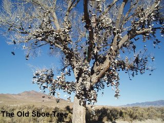
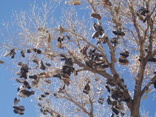
A few miles west of Cold Springs I rounded a curve and - "what's the matter with that tree?" I asked out loud. I could tell that the leaves had all fallen, but are those shoes hanging from the branches???? These questions formed as I passed. I was curious enough to look for a way to turn around and go back. It was about a mile before I could do just that. And, yes - the giant cottonwood tree was loaded with shoes. (see photos). I've since read that it is called "The Old Shoe Tree." The tradition of throwing shoes up is said to have started following an argument between newlyweds, during which one tossed the other's shoes into the tree. When they reconciled, the other reciprocated; and folks have been tossing their footwear into the tree ever since.

I passed a sign saying U.S. Navy Centroid Facility. What is that? OK, Navy friends, what is this?

Next as I came down a grade it looked like there was a huge lake ahead - on both sides of the highway. As I got closer, I realized that it isn't water. Rather it was somewhat like the salt lake beds that Tom, Jesse and I went to see in the Mountainaire area. It was rather squishy-looking, and in fact there were tire tracks here and there - some had sunk in quite a ways. This "lake bed" or whatever was on both sides of the highway for about 14 miles, extending a long ways to each side. Off in the distance was a huge mountain of sand that had ATVs crawling all over it. As I neared Fallon, I passed the Fallon Naval Air Station.

After driving through such isolated land and through such small towns, Fallon seemed huge and had a lot of traffic. Because I passed up Austin and drove more miles today than planned, I will spend two nights here in Fallon.

I settled in at the RV park at the Bonanza Casino. I have full hookups, a free roll of nickels for the one-armed bandits, a free bar drink and $2 off a meal at the casino restaurant! All for $15 for the night. I'm right across from a Walmart and Safeway store, a few blocks from a coffee shop with wireless Internet, and a few blocks from the main downtown. Tomorrow I'll explore this town.

Saturday, November 19, 2005
Well, Fallon isn't as big as I had thought. I explored the small downtown - just a few blocks long - and even though it is Saturday, several stores were closed. There's not much to see, but I did find a second-hand book store and stocked up on some books. I also cleaned the motorhome and did some shopping at Safeway. Tomorrow I'll drive the 80 miles to Gardnerville where I'll stay for several days. This will probably be my last post for a few days.

Thursday, November 17, 2005

Highway 50 - flat and "lonely"

Thursday, November 17, 2005

I'm in cattle country, so it was no surprise to see this bumper sticker:
Support beef - run over a chicken


Brrr. It got down to 16 degrees last night!

My first stop was at Mom's Café in downtown Salina. I had seen the huge billboard outside of town yesterday. Inside the café were numerous write-ups - mounted and framed - for all to see. I didn't know it was such a famous café. It had been a feature article in Sunset Magazine, National Geographic Traveler, and such. I had hopes of a delicious breakfast. But more often than not, these famous places are a let-down. My breakfast - two eggs, two hotcakes, and bacon - was a disappointment, and it was overpriced at $7.50!

Today's route, all on Highway 50, was beautiful in its own way. And it is a beautiful day for driving - clear and cold. The highway took me through several small towns, alongside the Fishlake National Forest and through some high desert lands. The highway was my kind of road! For miles it was pretty straight and mostly flat until I passed a large body of water named Sevier Lake, which usually is just a dry lakebed. There was hardly any traffic.

The Wah Wah Mountains are to the south; the Confusion Range, including the 9,655-foot-high Notch Peak to the north. It was 83 miles of basically nothing but short grasses and dead-looking short bushes. I stopped to watch three antelope grazing not too far from the highway. As I neared the Nevada border, I could see the Great Basin National Park mountains in the distance.
In Nevada, highway 50 is called "The Loneliest Road" - and it also is called the Grand Army of the Republic Highway. Right at the border, on the Nevada side, I passed up my first opportunity to gamble!

The road from the border to Ely, is all up and down. As I crossed the Snake Range at Sacramento Pass (7,154 ft) I could see snow-topped Wheeler Peak (highest one in Nevada at 13,063 ft). I dropped down into Spring Valley for several miles and then crossed the Schell Creek Range at Connors Pass (7,722 ft).

Good old Jeremiah! Just hums right along without complaining. I stopped for lunch at the Ely Elk lookout area. Across the highway is a buffalo preserve.

After settling in at the Old Prospector Casino, Hotel and RV Park, I found a wireless Internet site at a coffee shop about 8 blocks away. Tomorrow morning I'll post to my blog, email off some work, and spend some time exploring historic downtown Ely.

Two more nights out and then I'll be in Gardnerville (Nevada) for Thanksgiving and family time.

Wednesday, November 16, 2005

Behold the Beauty


Wednesday, November 16, 2005

Page (Arizona) to Salina (Utah)

“Once more I am roaring drunk with the lust of life and adventure, and unbearable beauty … Adventure seems to beset me on all quarters without my even searching for it … Though not all my days are as wild as this, each one holds its surprises, and I have seen almost more beauty than I can bear.”

The above quote is by Everett Ruess, an early explorer of the Grand Canyon area. And I echo his words - having just driven a little more than 200 miles from Page to Salina on scenic route 89. Amazing landscapes, intriguing and colorful mountains and mesas, trees dressed in their autumn colors and a clear blue sky provided oohs and aahs along the way.

Another quote I found - but forgot to get the author and the exact wording - was written while exploring the Grand Canyon/Page area. The gist of his comment was that 'this is worthless land and it won't ever amount to much.'

Just a couple miles out of Page I could see the Glen Canyon Bridge and Dam. Both are amazing feats of engineering. The bridge is 700 feet above the river, 1,028 feet long, and has a vertical rise of arch of 165 feet. It was built between 1957 and 1959. Before the bridge was completed, the road from one side of the canyon to the other was 250 miles, even though the visual distance separating them was only about 1,000 feet.

Once I crossed the bridge, I stopped at the visitor’s center and enjoyed the displays that includes construction pictures and quotes from early explorers. The dam, authorized and started in 1957, was completed in 1964. It is the second largest concrete dam and besides regulating Colorado River flow, it generates hydroelectric power. The lake it forms is Lake Powell and it is 186 miles long. (see photo above)

One I pass Kanab, Highway 89 is flanked by Navajo Nation lands, Vermillion Cliffs, Coral-Pink Sand Dunes, Zion and Bryce National Parks, and Dixie and Fishlake National Forests. It parallels the Sevier River that has created a fertile valley for farms and ranches.

At many places, the highway was right next to the river. I stopped and took a picture (see above).

At one of many tiny towns that are sandwiched between the mountains and mesas on both sides of the highway, a sign encouraged me to “see real fossil dinosaur eggs!” Sorry, not this time. The towns also had various Rock Shops – one was even constructed to look like a huge rock. A woodworker’s sign advertised “caskets, cedar chests and gun cabinets.” At one small town, a bunch of cars were lined up and had prices painted on the windshields – a normal used car lot? Nope. They were really old cars, the prices were barely visible and weeds had grown up. There’s an interesting story there!

Today’s drive ended at Salina, Utah. Before settling in at the Butch Cassidy RV Park, I drove through the small town to scope out a place for tomorrow’s breakfast – Mom’s Café. Once I was parked and set up, I explored the RV park and discovered quite an extensive aviary. The turkeys and chickens have the run of the park; the pheasants, dove and some birds I couldn’t identify are in elaborate cages. (see photo)

Oh, my gosh! I am so glad to be making this trip! What will tomorrow bring?

Tuesday, November 15, 2005

The “Carol’s” Debate


Tuesday, November 15, 2005

Yesterday as I was planning my route for today, the “two Carols” had quite a debate.
The pragmatic, thrifty, play-it-safe part of me doesn’t always agree with the whimsical, risk-taking, adventuresome part of me.

As I looked at the map with the two possible routes, adventuresome Carol said, “oh wow! Oak Creek Canyon! I haven’t been through Oak Creek in a long time and it will be so beautiful, it’s autumn, the leaves will be colorful. Then I’ll go into Flagstaff and on up to Page.”

Practical Carol said “yes, but, you are a slow vehicle and Sedona and Oak Creek are only narrow two lane roads and someone will be behind and be annoyed at the pace. It’ll take longer and probably take more gas going through Oak Creek. Just take the easy route – up to Winslow, Tuba City and then Page – because it will be less mountainous and quicker.”

It was interesting to hear the two sides of me. I mention this because many people think I’m so brave. Sometimes getting out of my comfort zone is easy, other times I have to talk myself into it.

Adventuresome Carol won the debate.

Today’s drive from Payson to Page was beautiful. All day the sky was a deep blue with not a cloud anywhere. The first part was forestland with its tall pines; the next part of my drive went through high, scrub oak rangelands and the towns of Camp Verde and Cottonwood. The drive through scenic Sedona with its colorful mountains followed by Oak Creek Canyon in full autumn color couldn’t have been better. Once I entered the canyon, there was hardly any traffic – so I could poke along and really enjoy the beauty. I took several pictures, but only one turned out good. (see photo)

Once I climbed out of Oak Creek, I skirted Flagstaff and headed north to Page. The Flagstaff mountain tops had snow. The last hundred miles today took me through barren, dry lands that had remnants of volcano action and the gorgeous, colorful – still practically tree-less – mesas and mountains. As I passed the historic Cameron Trading Post and crossed the deep gorge of the Little Colorado River, I could see the Grand Canyon in the distance.

There were so many picturesque scenes. Had I stopped to photograph them all, I’d still be on the road! And it was such a bright day, the ones I took were quite washed out. One picture (see above) turned out pretty good

I stopped for a late lunch at Cameron. This trading post has a lodge, RV park, art gallery, and restaurant. I had the Navajo traditional “taco” while enjoying the view of the Little Colorado. This trading post has served Hopi and Navajo people. The restaurant had a huge stone fireplace and antique furnishings.

The swayback suspension bridge that was built in 1911 over the Little Colorado was the first easy access over the gorge. It parallels Hwy 89 at Cameron.

Just past Cameron, I saw a series of signs – the first one said “Chief Yellowhorse (heart) you!” And the last sign past the establishment said “Chief Yellowhorse says turn back now!” Guess he really wanted to see me – but not this trip.

Before settling into the Page-Lake Powell Campground, I drove through town. Page had its beginnings in 1959, shortly after Congress authorized the Glen Canyon Project (the dam).

Tomorrow I’ll go across Glen Canyon Bridge, through Kanab and up scenic Hwy 89 to Salina where I’ll spend the night.

Monday, November 14, 2005

Benson to Payson and a small fright


Monday, November 14, 2005

How would you like to be driving 60 mph down the multi-lane freeway, look up toward the rear view mirror and see a monstrous grasshopper – inside and just a couple feet from your face? This guy was at least 4 inches long when he stretched out one of his legs, and he didn’t look any too friendly.

I didn’t know how he got in or how long he’s been in, but I did know that I wanted him out. My eyes darted from the grasshopper to the traffic, working my way into a lane to exit the freeway. I pulled in a gas station, opened the passenger side window and with a little encouragement from my flyswatter, he hopped right out. Whew!

That was the biggest excitement on my drive today from Benson to Payson (Arizona). I was on I-10 between Benson and Tucson and in the middle of nothingness a sign said “Tucson City Limits” – and shortly after that a sign said 21 miles to Tucson!

I had my CB on and was entertained by trucker talk. I stopped at Beaudry’s RV on the east side of Tucson to pickup the jacket I won as a door prize.

I headed north on Hwy 89. It was a beautiful day – no wind.

I’m at the Payson Campground and RV Resort for the night. The park is on 14 acres among the pines. (see photo) There is a blue jay just outside the open window that is squawking at Cat. Cat is wishing to go outside.

It’s early to bed tonight. Good night!

A laugh from Jeremiah (my Winnebago)

My friend Maria Negri sent this to me a while back, and I've been meaning to put it on my blog to give you a laugh!

A blonde goes into a coffee shop and notices there's a "peel and win" sticker on her coffee cup. So, she peels it off and starts screaming, "I've won a motorhome!I've won a motorhome!"

The waitress says, "That's impossible. The biggest prize is a free Lunch.?"

But the blonde keeps on screaming, "I've won a motorhome! I've won a motorhome!"

Finally, the manager comes over and says, "Ma'am, I'm sorry, but you're mistaken. You couldn't have possibly won a motorhome because we didn't have that as a prize.

The blonde says, "No, it's not a mistake! I've won a motorhome!"
And she hands the ticket to the manager and HE reads
"W I N A B A G E L"
That's it for a day or so.

Sunday, November 13, 2005

It was a good maintenance seminar

Sunday, Nov. 13, 2005

My “day off” last Thursday was productive and fun. The RV park has wireless Internet capabilities ($4 per day) and I sure got my money’s worth. It was fun reading through emails from friends, took care of a lot of business-related communication, and browsed through websites that are helpful to RV-ers. And I called brother-in-law Bob Lechien to have him handle the details for getting a new vent covers (to replace the lost one and to add a new feature to both my vents) ordered and an appointment to have them installed while I’m in Gardnerville for Thanksgiving.

After getting directions, I set out on my bike to go to downtown Benson. It was several miles each way and I had been alerted to the “big, mean hill” that would really challenge me on the ride back. No problem, I’m in good biking shape (thanks to the Nice People I ride with when I’m at home) – or so I thought. When I got to the top of the hill that drops into Benson, I had second thoughts. It was a very steep grade. I don’t mind coasting down but I definitely would end up walking my bike back up. It didn’t take long to decide to lock up my bike and finishing the trip to town on foot.

Lacking a bike to ride around town, my exploration was limited. I found some interesting information, though. Benson is located about 40 miles east of Tucson. I found it interesting that in 1878 – before the town was founded – an enterprising German who lived in this area built a toll bridge over the nearby San Pedro River! The town, located in the San Pedro River Valley, was founded in 1880 to serve the Southern Pacific Railroad and nearby mining activity. As the demand for copper and silver grew, so did the town. The original six streets were named after the principal mountain ranges and rivers of the region. Safeway, the only real grocery store, is located on one of those early streets.

The maintenance seminar started Friday morning and ended Sunday morning. Thirty RVs were here; many of the attendees are full-timers. One lady, driving the smaller Winnebago Aspect just turned 80! She’s been RVing for nearly 30 years. The most interesting – and most valuable – parts of the event were the presentations by RV technicians. The two men patiently went through all the subsystems in motorhomes and answered all questions. They also spent one afternoon going from RV to RV to help with specific problems. I’m glad I participated.

Today is a much-needed day off. I did three loads of laundry and cleaned my rolling home. Tomorrow morning I’ll head west to Tucson, stopping at Beaudry RV to pick up the jacket I won as a door prize, and doing some RV shopping at Camping World. I also have a Walmart list. From there I’ll head north and probably spend the night at an RV park in Payson. I just checked the weather and it looks like clear, sunny days for the next few days.

Here’s what I found in today’s reading:

Where are you today on your own journey? Are you discounting the significance of your days? Are you sighing rather than singing?

Thoughts are the thermostat that regulates what I accomplish in life. If I feed my mind upon doubt, disbelief and discouragement – that is precisely the kind of day I’ll have. If I adjust my thermostat forward to thoughts filled with vision, vitality and victory, I can count on that kind of day.

Wednesday, November 09, 2005

The drive to Benson, Arizona

Wednesday, Nov. 9, 2005

Well somewhere between Columbus (NM) and Benson (AZ) there is a white plastic vent cover that belonged to Jeremiah. I didn’t even know it was missing until I was set up at the Cochise Terrace RV Resort and turned the crank to open the vent. Surprise!

I did have a lovely drive today. I left Columbus, stopping first outside the library to check the Internet, and drove east on NM 9. This rarely-traveled road pretty much parallels the NM/Mex border. In about 70 miles, I met only 8 vehicles on the road – along with several Border Patrol and National Guard vehicles, including three tanks! As I neared the Arizona border, I drove 20 miles north to I-10. This Interstate goes through several small towns including Bowie (cotton and pecans are major agriculture crops here) and Wilcox (home of the Rex Allen museum and a Rex Allen statue that features a bronze heart in the interior of the chest cavity. “This was a special request by Rex so his heart will always remain in Willcox.” And this small town has a Dairy Queen!

The entire southeastern corner of Arizona – from I-10 south to the AZ/Mex border and from the NM/AZ border to Benson – is called “Arizona’s Heartland.” This area boasts the state’s largest assortment of direct-sales farms. In season you can buy nuts, vegetables, meats, honey, jellies, and baked goods from roadside stands.

Tomorrow is a “day off” for me – a chance to get some RV chores and writing done.

Here’s the last of the Farmer’s Advice:

* If you find yourself in a hole, the first thing to do is stop diggin'.
* Sometimes you get, and sometimes you get got.
* The biggest troublemaker you'll probably ever have to deal with, watches you from the mirror every mornin'.
* Always drink upstream from the herd.
* Good judgment comes from experience, and a lotta that comes from bad judgment.
* Lettin' the cat outta the bag is a whole lot easier than puttin' it back in.

P.S. I have figured out how you can post comments without having to "register", so feel free to post comments, or simply email me: carolinnewmexico@azulstar.com

Tuesday, November 08, 2005

Village has fascinating history


Travel is more than seeing of sights. It is a change that goes on, deep and permanent, in the ideas of living. - Miriam Beard, historian

Yesterday's tour of the village and today's time at the historical museum in the village and the small temporary museum at the RV Park does remind me of how blessed I am.

As to the history of the area, it is extremely interesting. Here's a very condensed version:
In 1902 the El Paso and Southwestern Railroad was completed, and a depot was built to handle the three trains a day.

In 1912, the U.S. 13th Cavalry set up Camp Furlong just south of the depot; this increased the trains to 10 a day. As its name implies, this was a mounted army that had horse/mule drawn supply wagons.

At that time the village - looking just like those movie-set towns in old westerns - also had two hotels, several stores and a bank in the business district, a school and homes.

Before daylight on March 9, 1916, Mexican bandit Pancho Villa and his 600-plus bandits (Villistas) raided the village of Columbus and the Army's Camp Furlong. It was completely unexpected. Villa's final staging place for the raid was the property that now makes up Pancho Villa State Park, which is across the road from the railroad station.

Villagers and army personnel were sleeping. When the army was alerted, it took some time to find the keys that would unlock the armory where all their guns and ammunition were stored.
Practically every business was broken into and looted, and the rickety wooden buildings were burned. The raid lasted until just after daylight. When the Villistas retreated, they were briefly pursued by 59 troopers and four officers. Eight soldiers, ten civilians and two hundred-plus Villistas died in the raid.

One week later, General John J. Pershing entered Mexico with several thousand troops in pursuit of Villa. They chased him around Mexico - called a Punitive Expedition - to no avail before returning to Camp Furlong 11 months later.

Camp Furlong was the site of the first army/air corps airfield, saw the first of the motorized support vehicles - and built the first elevated "grease rack" to maintain those vehicles. Several of these vehicles and early airplanes are at the park and will soon be housed in a new military museum there.

After roaming the museums, I was invited to join the L.O.W.s for their weekly trip to the Pink Store/Restaurant across the border in Palomas. (LOW stands for Loners on Wheels)This is a national organization for singles; one of their club-owned RV parks is nearby in Deming. The restaurant serves "Mexican, Mexican food" as opposed to New Mexican, Mexican, etc. There were about 30 for the lunch. The Pink Store serves a complimentary Margarita, and they don't skimp on the alcohol!

Here is more of the Farmer's Advice:

* Every path has a few puddles.
* When you wallow with pigs, expect to get dirty.
* The best sermons are lived, not preached.
* Most of the stuff people worry about ain't never gonna happen anyway.
* Don't judge folks by their relatives.
* Remember that silence is sometimes the best answer.
* Live a good, honorable life. Then when you get older and think back, you'll enjoy it a second time.
* Don't interfere with somethin' that ain't botherin' you none.
* Timing has a lot to do with the outcome of a rain dance.

Monday, November 07, 2005

Hooray for the Internet!


Monday, Nov. 7, 2005

It was a gorgeous New Mexico winter morning! I remembered to take a photo for you.

I was at the Patio Café when they opened at 8 - for breakfast and some Internet time. My first priority was to post to my blog, then to read important-looking email. I was happy to see more articles and information come in for the Personal Chef magazine that I've been working on. Fortunately the café never needed my table, and the waitress said I could stay as long as I wanted.

When I finished, I biked around town and took some pictures - the main part of the village (population 1,500) and an old trailer converted to living quarters. Columbus is a poor town, the majority of homes are run-down places with dirt "yards" and one or more inoperable vehicles. Up until several years ago, the population was made of up Mexican field workers and some Anglo old-timers. Signs posted on the town message board are mostly in Spanish. The newcomers to town seem to be retired folks who have found inexpensive real estate both in the village and outside.

The park ranger said that last night the Border Patrol had gotten a tip that a couple groups of "alleged" illegals had crossed the border, and that's the reason for the helicopter activity. They said that between the National Guard and Border Patrol personnel, quite a few were rounded up.

One of the motorhomes that parked nearby yesterday has two dogs on leashes outside. Cat seems content to stay in the motorhome, even when I have the door open. I tried explaining that the monsters were tied up and couldn't get her, but evidently I wasn't convincing.

A friend emailed some "Old Farmers' Bits of Wisdom."
I'll end today by sending you some of them.

* Your fences need to be horse-high, pig-tight and bull-strong.
* Keep skunks and bankers and lawyers at a distance.
* Life is simpler when you plow around the stump.
* A bumble bee is considerably faster than a John Deere tractor.
* Words that soak into your ears are whispered...not yelled.
* Meanness don't jes' happen overnight.
* Forgive your enemies. It messes up their heads.
* Do not corner something that you know is meaner than you.
* It don't take a very big person to carry a grudge.
* You cannot unsay a cruel word.

Sunday, November 06, 2005

A quiet Sunday in Columbus - until the border patrol helicopter shows up

Sunday, November 6, 2005

It's a quiet day in Columbus - as I bike around, everything is closed except for the one-and-only gas station, the museum at the historical railroad depot, and a small Mexican café (menudo today, announces their sign).

I've got some sort of allergy-thing going on. Thankfully I have a pretty well-stocked box of remedies, including cold, flu and allergy. I don't feel especially bad, just very stuffed up and sneezy.

A number of RVs arrived, including some from the Silver City Elks for their annual pre-Thanksgiving week/dinner and some from the Border Cities Winnebago Chapter. It was a good day for visiting. There are four other solo women RVers here today - and they all are full-timers.

I spent time with the camp host/volunteers: two couples and one single lady. I located a motorhome that has satellite Internet and spent time talking to them about it.

It was a lazy day. I settled in early this evening because the "no hear-um mosquitoes" are here, also. As I started reading, I heard a helicopter fly overhead - again and again. I went out and noted that they are circling and have a couple powerful spotlights aiming down. Must be something involved with the border patrol; after all, we are just three miles from the border and this area is a major thoroughfare for illegals. Realizing that the helicopter was focusing on the RV park area, I quickly went back in and made sure all doors were locked. It's now been about 15 minutes, and they are still at it. It will be interesting to talk with the park rangers tomorrow.

That's it for today. Glad I'm safe and secure in Jeremiah and my bike is double locked. Tomorrow I'll head to the café and/or library and get my blog posted. And I'll take some pictures.

Saturday, November 05, 2005

Today's driving day ends with surprise!

Saturday, Nov 5, 2005

With a goal of traveling through Deming, a one-stoplight small town on I-40, and ending at Columbus, a teeny-tiny village on the New Mexico/Mexico border, I got an early start. The drive took me through a major agricultural area and then plenty of open nothingness - a 100-mile drive.

In Deming, I restocked some supplies at Walmart, and then set out to find Internet access. No luck. But---a man at the visitors center said there was wireless Internet in Columbus!! What a surprise! The village received a grant to install wireless in the town's library. What good news to me because Pancho Villa State Park, where I'll be staying, is just about four blocks from the library. Finally, I could get on the Internet again.

Once I got to the village, I headed straight to the library only to find that a technician was working on the system so it wasn't available. But, the librarian said, the café across the street also has wireless!

After settling in at Pancho Villa, I put my laptop in my backpack and bicycled over to the café for lunch and computer time. I had over 200 email messages waiting for me! I made a little progress, but ran out of time to post to my blog.

I spent the rest of the afternoon walking and visiting with other folks in the park. Cat did some near-by exploring. Ever since her encounter with "the monster" at Percha, she doesn't stray very far. It is a fairly large RV park in a desert setting, but only about a dozen RVs were here. I'm looking forward to a quiet night.

I'm reading an enjoyable and funny book by Bill Bryson - The Lost Continent; travels in small-town America. Born in Iowa, Bill sets out to find the "perfect small town." His humor is similar to Dave Barry's. Newsweek magazine said of the book: "The Lost Continent is paradoxically touching - a melancholy memoir in the form of snide travelogue." I'm about three-fourths of the way through the book, and he's still looking for that special town.

His book is interesting because I prefer to drive the state highways and county roads that take me through small towns. And since I don't try to drive many miles in a day, I have time to park and walk down "main" street. I have no problem finding someone interesting to talk to.

Friday, November 04, 2005

Jeremiah - all the important creature comforts

Friday, November 4, 2005

Counting all my trips so far, I've been out and about in Jeremiah for a total of 15 weeks since I bought him last Christmas. Never once have I regretted buying my motorhome. Never have I wished for a larger one or a smaller one. This one is a perfect size for me. With or without the slide extended, I never feel cramped for space. I have all the important comforts of home while traveling.

The only feature I wish for is a satellite dish for Internet access, especially since I'm working parttime. I'm starting research on what is involved and the costs.

Today was another fairly lazy day for reading and taking short walks. This evening was another dinner at the Eagles' Lodge with Bob and Joyce (camp hosts). The menu was Gorditas, beans and rice. It was fun, and a couple of people remembered me from last week. Another person asked me if I was going to join!

I have decided to leave in the morning and head for Pancho Villa State Park. It is located in Columbus, NM, and is just three miles from the Mexican border. I'll be there until Wednesday morning. I've been there before, but don't recall if I'll have cell phone service. But, who cares?!?

Each day I read a portion of Charles Swindoll's book, "Wisdom for the way: Wise words for busy people." I always find something to ponder. This was in today's reading:

The good life - the one that truly satisfies - exists only when we stop wanting a better one. It is the condition of savoring what IS rather than longing for what might be. Satisfaction comes when we step off the escalator of desire and say, "This is enough. What I have will do."

I am living the good life; I'll count my many blessings as I fall asleep tonight.

Thursday, November 03, 2005

Thinking about moving on


Thursday, November 3, 2005

Another blustery, windy day set in about mid morning, just as I was contemplating unhooking and driving into Truth or Consequences for some shopping and hopefully to find a way to access the Internet.

The wind changed my mind. I decided to make today another working day and made good progress. Three RVs arrived during the day, giving me opportunities to take breaks and visit.
I went to great pains to take pictures of a field of chiles. (see photo) What was the pain? Chile plants aren't very tall, and to get the photo angle I wanted, it was necessary to lie down in the dirt - long enough for an unknown insect to give me a painful bite on my knee! I had wanted to take pictures for several days, but put it off. In the meantime, we had a few nights of below freezing temperatures that froze the plants' leaves. I was told that the farmer is intentionally letting the chiles dry on the plant rather than picking them and then mechanically drying them at the packing shed.

I am considering moving on to Pancho Villa State Park at the border town of Columbus, NM, on Saturday. The drive takes me through Deming where there is a Walmart and I think I'll have a good chance of Internet access.

Today's posting is not complete without an interesting quote by Beverly Donofrio, author of "A Roof of One's Own":

If you say yes to yourself,
If you let your imagination fly,
If you open one stuck, fear-warped door,
Other doors you never even noticed fly open,
Pushed by a spirit strong as a hurricane.

Wednesday, November 02, 2005

Enchiladas highlight another great day


Wednesday, Nov. 2, 2005

The highlight of my day was Joyce's awesome enchiladas and learning to make the sauce. I normally avoid red chile sauces because they often taste bitter, but the sauce she made was so smooth and flavorful. The enchiladas - flat, not rolled and with a fried egg on top - were delicious. I'll definitely stop and buy dried red chiles on my way to Arizona -no more canned sauce for me. (Note to the Nice Friends: let's have a New Mexican potluck dinner when I get back - I'll make the enchiladas.)

Earlier in the day, with a list of phone calls that needed to be made, I bicycled to the corner of "nowhere and nowhere" where I can get cell phone service.

Each day I continue my reading and thinking time, walking or sitting along the river, and writing in my journal. I'm never bored.

With the threat of "the monster" ever lurking, Cat stays close to home; and at times even with the door open, she chooses to stay inside. She has been perfecting the art of napping, trying out numerous positions and locations. (see photo of one of today's naps)

Today's pithy statements:

Life is like a coin;
you can spend it any way you wish, but you spend it only once.

Nothing in 'fine print' is ever good news
Science is facts.
Just as houses are made of stone.
But a pile of stones is not a house
And a collection of factsIs not necessarily science.
(quote attributed to Henry Poincare)

That's it for today.