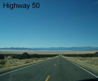
Highway 50 - flat and "lonely"
Thursday, November 17, 2005
I'm in cattle country, so it was no surprise to see this bumper sticker:
Support beef - run over a chicken

Brrr. It got down to 16 degrees last night!
My first stop was at Mom's Café in downtown Salina. I had seen the huge billboard outside of town yesterday. Inside the café were numerous write-ups - mounted and framed - for all to see. I didn't know it was such a famous café. It had been a feature article in Sunset Magazine, National Geographic Traveler, and such. I had hopes of a delicious breakfast. But more often than not, these famous places are a let-down. My breakfast - two eggs, two hotcakes, and bacon - was a disappointment, and it was overpriced at $7.50!
Today's route, all on Highway 50, was beautiful in its own way. And it is a beautiful day for driving - clear and cold. The highway took me through several small towns, alongside the Fishlake National Forest and through some high desert lands. The highway was my kind of road! For miles it was pretty straight and mostly flat until I passed a large body of water named Sevier Lake, which usually is just a dry lakebed. There was hardly any traffic.
The Wah Wah Mountains are to the south; the Confusion Range, including the 9,655-foot-high Notch Peak to the north. It was 83 miles of basically nothing but short grasses and dead-looking short bushes. I stopped to watch three antelope grazing not too far from the highway. As I neared the Nevada border, I could see the Great Basin National Park mountains in the distance.
In Nevada, highway 50 is called "The Loneliest Road" - and it also is called the Grand Army of the Republic Highway. Right at the border, on the Nevada side, I passed up my first opportunity to gamble!
The road from the border to Ely, is all up and down. As I crossed the Snake Range at Sacramento Pass (7,154 ft) I could see snow-topped Wheeler Peak (highest one in Nevada at 13,063 ft). I dropped down into Spring Valley for several miles and then crossed the Schell Creek Range at Connors Pass (7,722 ft).
Good old Jeremiah! Just hums right along without complaining. I stopped for lunch at the Ely Elk lookout area. Across the highway is a buffalo preserve.
After settling in at the Old Prospector Casino, Hotel and RV Park, I found a wireless Internet site at a coffee shop about 8 blocks away. Tomorrow morning I'll post to my blog, email off some work, and spend some time exploring historic downtown Ely.
Two more nights out and then I'll be in Gardnerville (Nevada) for Thanksgiving and family time.

<< Home