Up and over the mountains to Brantley Lake State Park
Well, no luck finding a wireless Internet access in Alamogordo on a Sunday morning – so there was no opportunity to post to my blog. After a stop for gas and another to dump my waste tanks, I headed east and UP!
The altitude at Alamogordo is a little more than 4,000-feet – and after only a mile on highway 82, I started a 16-mile climb up the west flank of the Sacramento Mountains to the village of Cloudcroft – at 9,200 feet. One of my travel books said I was passing through “all the climatic zones from the Sonoran Desert region of Mexico (creosote bush and cacti) to the Hudson Bay region of Canada (spruce, fir and aspen).” Jeremiah is such a trooper, climbing with relative ease. This route took me through a tunnel – a rarity in New Mexico – the villages of High Rolls and Mountain Park.
From Cloudcroft, I gradually descended to the town of Artesia. This probably started as a small town in a lush farming area, watered by artesian wells (thus the town’s name of Artesia). Then oil was discovered and then town grew.
I took pictures of the local huge monument dedicated to the men and women who take the risks and do the work to find, produce and refine New Mexico oil and gas. It is a full-size replica of a 1950’s drilling rig; it was unveiled in 2004 in celebration of the 89th anniversary of the first commercial oil well in that area.
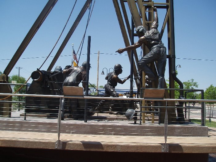

“Make no little plans; they have no magic to stir men’s blood.”
– Daniel Burnham, architect 1893, Chicago World’s Fair (on one of the plaques at the drilling rig monument)
At Artesia, I turned south on highway Less than 24 miles later I was pulling into Brantley Lake State Park – and into space #39! It is indeed a good site. Closest neighboring sites are at least 50 to 70 yards away, and there is nothing but brushy land between the lake and Jeremiah. I’ll be eager to explore the trails that lead to the lake. I have a cabana, picnic table and a windbreak wall.
Facts about Brantley Lake and the State Park
Created by building a dam on the Pecos River, 12 miles north of Carlsbad, New Mexico.
The resulting lake “drowned” the wild-west town of Seven Rivers, one of the wildest towns of the Old West.
Because of the on-going drought, all New Mexico lakes and rivers are low.
The park is home to numerous wildlife: raccoon, javelina, pronghorn, mule deer, kangaroo rat, bobcat, badger, hare and rabbit, skunk, gray fox, coyote, lizards, snakes and porcupine.
Also, a good variety of birds and waterfowl.
Everywhere you look in this harsh environment you’ll see creosote bush, mesquite and acacia, agaves, yucca, prickly pear and other cactus and succulents.
The altitude is about 3,000 feet.
I worked up a sweat getting Jeremiah leveled and hooked up and the air conditioner on – yeah! Electricity again! Outside temperature is in the high 80s to low 90s. With a cold bottle of water, I walked around the camping area. The 51 spacious campsites, all with electricity and water hookups, are arranged around a large figure-eight.
I stopped to meet a couple – Paul and Betsy (and their traveling companion: Bumpy a black rabbit) from Florida. The two of them have an adventurous spirit and an interest in history and outdoor activities – my kind of people! They are on their way to a “work camp” job (camping space and utilities in exchange for work) at a camping park just outside of Ruidoso. They also want to move from Florida and will be looking around New Mexico.
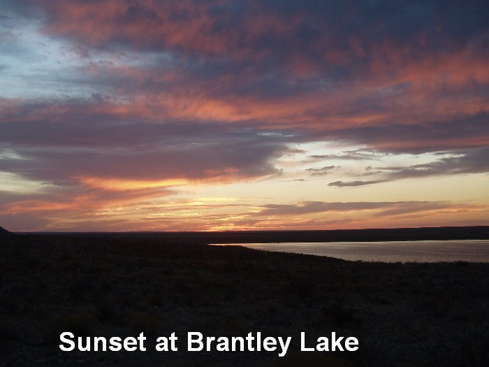
This evening’s sunset was gorgeous! Here’s a picture of it.
posted by Carol A. Anderson @ 11:09 PM
![]()

<< Home